The Battlefield
The location of the battle in the parish of Edgcote seems incontrovertible. Contemporary sources describe it as the battle of Edgcote and one (Hearne’s Fragment) specifies it was fought on the land of a certain Clarell. This was Richard Clarell, lord of the Manor of Edgcote who died in 1478 and whose land was subsequently subject to a legal dispute.
The main landscape clues for the location of the battle come from Waurin, who says the battle was fought across a water course, and Hall who identifies three hills between which the fighting occurred. But the Manor of Edgcote stretched over a large area, from the Cherwell in the north almost to Thorpe Mandeville in the south and bordered on the lordships of Culworth and Wardington in the east and west respectively. The landscape described by Waurin and Hall in and around the Manor lands is difficult to identify conclusively as several different possibilities arise. However, one further clue, offered by Stow in the late sixteenth century, helps focus the search. Stow indicates the battle was fought on Danes Moor. How he knew this over one hundred and twenty-five years after the battle is unclear, though he might have relied on local tradition.
Danes Moor is marked on the modern Ordnance Survey map on the boundary of the Edgcote and Culworth estates, but this is a more limited area than was probably the case historically. The earliest known survey of the Edgcote estate dates from 1742. Whilst more work is required to understand which parts of the estate were added between the date of the battle and the survey being drawn-up, Danes Moor is identified within this survey as a field (also called Davis’ Meadow) directly to the west of Danesmoor Spinney in the area north of Danes Moor marked on the modern Ordnance Survey map. That there is reference to Danes Moor in these separate but close to one another locations is indicative of a wider area of land was known by this name at the time of the battle.
A moor, in this region at least, was typically an area of low-lying land which was periodically wet and thus unsuitable for arable cultivation. The ground could be marshy, where springs emerged, or include flat areas of clay with waterlogged ground. Moors were incorporated into open fields in Northamptonshire in the medieval period as evidenced by ‘moor’ references in furlong and field names in places such as Braybooke. Here, to the east of the village, the moor was lost to medieval arable expansion.
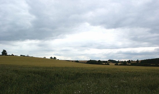
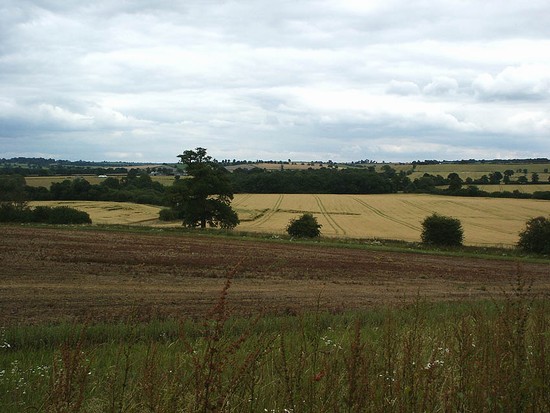
To identify Danes Moor, in the absence of definitive documentary evidence, one needs to locate low-lying areas which were never cultivated in ridge and furrow. These areas can be quite small, but indicative of a wider area of moor that was subsequently given over to agriculture. Examination of the air photographic evidence for the parish as it was in the 1940s (see the images in the download area) reveals very extensive survival of ridge and furrow, the earthwork remains of the medieval open field system. There appear to be four areas lacking ridge and furrow in Edgcote. The first two can be dismissed as they represent the site of the medieval village of Edgcote, now deserted, and the meadow on the alluvial area along the floodplain of the river Cherwell, which is highly unlikely ever to have been described as moor. This leaves two areas. The first is on the top and the very steep north facing slopes of Edgcote Hill in the south of the parish, the wrong topographical location for the moor. The other is the floor of the valley at the south eastern edge of the parish. Here, in the upper part of a small side valley to the main Cherwell valley, there are areas of flat valley floor which lacked ridge and furrow. One is within part of the field shown as Danes Moor in the 1742 survey which also extends to the south west into the area of Danes Moor shown on the modern Ordnance Survey map. The other follows a now lost west-east tributary of the stream marking the eastern boundary of the estate which flows to the west of Culworth Hill. Between them was a large block of ridge and furrow. This is a wide flat area on Upper Lias Clay and so will have historically been poorly drained
Danes Moor, the site of the battle, is described as Hegecote seu Danysmore in the 15th century. (Gover, 1933, The Placenames of Northamptonshire, p.34, quoting MS Tanner 2, f.104, Bodleian Library). On Eyare’s map in 1779 and 1791 it is described as Dunsmore. According to Gover the derivation of the name is obscure but certainly does not refer to Danes, though by tradition, recorded by Morton (p.542) and by Beesley (p.56), in the 18th and 19th centuries the moor gained its name as the place of a battle between Saxons and Danes in the 9th century. Eayre’s map of Northamptonshire in 1779 & 1791, followed by Bryant’s of 1826, both show Danes Moor as the area of the Cherwell valley in the north east part of the parish running up to Trafford bridge. This is also the area that described as Danes Moor by Beesley in 1841, who places it immediately to the west of Danesmoor Spinney. However the Northamptonshire county historian Baker, writing in 1822 (p.500), is very specific that ‘Danesmore (for so it was certainly called as long since as 1469) or Dunsmore (as the Countrey People now frequently call it) a pretty spacious Valley on the South of Edgecote…’. He also says that ‘The spot now called Danesmoor is a small plantation of a few acres, but the name at this period had doubtless a much more extended application.’ There is no land between the Cherwell and the spinney which would seem to accord with the description of moor, ridge and furrow apparently covering all this area between the meadow beside the Cherwell and Edgcote Hill. In contrast the upper reaches of the side valley, to the west and south of the spinney, fit very well with the description of a moor.
When Hall described the battle, he said there were three hills of different heights in an almost triangular configuration between which the battle was fought. Beesley’s interpretation of the location of the battle, followed by various later authors, led him to interpret Hall’s description of the three hills as Wardon Hill to the north of the Cherwell, Edgcote Hill immediately to the south west and that to the east as the hills in Culworth. These then lie on the three sides of the wide plain formed by the river Cherwell, though it does involve the distortion of the compass locations of the hills as described by Hall. However, Hall’s description of the battle seems to imply that the hills were fairly close to each other. He certainly states that Pembroke was on the west hill, the rebels on the south and that the rebel reinforcements approach over the hill on the east, with the action being fought on the plain between the three hills.
The small valley identified above as Danes Moor does indeed have three hills of different heights surrounding it. The floor of the valley is quite wide and would accord well with the plain described as lying between the three hills, where the action was fought. This has been the site of the battle as described by several authors, an interpretation considered but dismissed by Haigh, in favour of the site first described in detail by Beesley. If one reverts to the former site then all the accounts, limited though the topographical information may be, seem to fall into place. The hills are of different heights but form a very rough triangular area within which lies the spacious plain. The rebel troops coming late to the battle from Northampton would have approached, as the accounts say, over the eastern hill, along the route via Culworth from the Banbury Lane, the main route from Northampton to Banbury. On the south the hill initially occupied by the rebels lies close to the Banbury Lane, which seems quite likely to have been the approach of the rebels, who were certainly near Northampton when the first skirmishing of the campaign took place the day before the battle. Finally, the western hill, where Pembroke’s forces were initially deployed, could have been approach from the west, via Wardington and the main road which leads from Banbury towards Daventry. This was a major route leading via Banbury, where we know Pembroke was the day before the battle, to the north east midlands where Nottingham was the Earl’s objective.
The one other topographical element is that provided by Waurin, who says that the two armies camped on either side of a small stream or river the night before the battle and then fought across the same stream or river the next day. Partida, Hall and Foard’s work (see further reading) shows a tributary of the Culworth Hill stream running between the southern and western hills. It would be difficult to describe this as anything more than a brook but with Waurin relying on second hand accounts and possibly then having to translate them into French if they had been first received in English, it is possible the description of the watercourse, particularly given its apparent tactical significance, became enlarged. Alternatively, as Evans and Northampton Battlefields Society have argued, the Culworth Hill stream, which is more substantial, is the watercourse in question. This does flow in front of the southern hill occupied by the rebels before the battle, then turns north and passes to the west of Culworth Hill before joining the Cherwell and could be said to be between the two encamped armies.
Based on the above analysis, the general area of the battlefield can be located with some confidence. Final, confirmation of the orientation of the action is likely only to be achieved by an intensive, accurately mapped and systematic archaeological metal detecting survey.


