Details of Historic Terrain
River
The river runs on almost exactly the course it did in the 14th century and, because the navigation cut runs to the north of the bridge it means that the character of this short stretch of the river adjacent to Boroughbridge may not have been changed as those sections of river directly affected by the 18th century navigation works. The river is some 40 metres wide and may have been little wider in the 14th century. However the river levels may well have been changed by the weir upstream of the bridge and the works further downstream from the bridge. The ground on the south side of the river, at least downstream of the bridge is slightly lower than that on the north bank, which may have made it even easier for Harcla’s archers to drive off Lancaster’s cavalry attack. Adjacent tot eh town it is possible that ground levels on the town side have been raised since the time of the battle.
Roads
Boroughbridge has been a waypoint on one of the great roads of England throughout the medieval and post medieval period. The Great North Road was first mapped as running through Boroughbridge in circa 1250 and other major routes, including the one across the Pennines to Carlisle, was mapped in circa 1350, while Ogilby provides detailed evidence for these and other routes through Boroughbridge in 1675.
The road alignments to north and south, beyond the town, give the impression of a route which originally crossed the River Ure some 300m upstream from the present bridge. It is possible that this was the site of an original Saxon ford crossing the Ure, though this is pure conjecture. Boroughbridge itself sits just to one side of this alignment, along either side of a small stream that joins the Ure just below the present bridge. It may be that the road was re-aligned in the medieval period when the town was founded or when the first bridge was constructed, a century or more before the battle. The layout of roads and settlement here is however complicated by the confluence of a small stream with the river Ure, extending the floodplain up between the two main roads in the town. As there has apparently been no detailed study of the evolution of the topography of the town it is difficult to be sure about the exact layout of the town or indeed the exact position of the river crossings, either the bridge or indeed the ford, that figures in the accounts of the battle.
Bridge
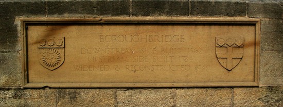
The bridge of 1322 was built of wood. By the time Leland visited in the 1540s it had been replaced in stone and it is also described by Camden in 1582. The plaque on the bridge states that it was built in 1562, rebuilt on the upstream side in 1784 and widened in 1949. Despite the extensive rebuilding, remains of the 16th century structure seem to be visible on the downstream side, particularly in the southernmost (town side) arch when viewed from the north bank.
Ford
The major problem of interpretation of the battlefield is the location of the ford. Authors since at least Barrett, who suggested it might lie on the line of the Roman road, have accepted that the ford lay 800 metres to the east of the present bridge and close to Milby, where the Roman road running past the Roman town at Aldborough, crossed the Ure.
The exact location of the Roman crossing has been established from the cropmark and other evidence. However the apparent presence of a paleochannel in this location, visible in the extent of alluvium, may further complicate the issue, if it was open in the medieval or indeed the Roman period. The river course is essentially the same on the Tithe Map as today, but the navigation works were completed in the 1770s and so earlier course of the river may not have been identical to that seen on the 19th century mapping.
However no clear evidence for this ever seems to have been presented to justify this identification. No evidence for the continuance of such a route has been founding on the 19th century mapping consulted for this report, but detailed documentary research is required to resolve the issue. The Roman road will have crossed the river on a bridge and it is possible that here, as in some other Roman river crossings nationally, the Saxon and early medieval road system was diverted from the Roman crossing because it was unsuited to fording.
The early importance of the Great North Road might suggest that in the Saxon period it crossed the Ure by a ford before the construction of the bridge. Indeed, it is possible that, as with some other medieval bridges, a ford was also maintained particularly for heavy traffic or perhaps also because the ford may not have been subject to tolls as bridges often were. The way in which Boroughbridge itself is off-set to the east from the main alignment of the major roads as they approach from both north and south, may imply that the medieval ford lay on an original alignment, to the west of the town. Although this is pure conjecture, it is presented in order to demonstrate the need for a detailed study of the historical topography and archaeology to resolve a fact that is central to the interpretation of the battle. Other locations also need to be considered, including one in close proximity to the bridge, for none of the main contemporary sources specify which side of the bridge the ford lay, let alone what distance from the bridge.
The land of Aldborough was largely open field in the medieval period, much of it remaining open until 1809. If the ford lay well to the east of Boroughbridge, on the Roman crossing, or to the west then it is likely that it lay in open field meadow, which encompassed most or not all of the floodplain until the early 19th century.
The Town
The settlement took its name from the bridge and is first referred to in 1155, when it was granted borough status. Thereafter it grew to be a substantial market town. The town was a chapelry of Aldborough and was clearly created by taking out a small section of that township on either side of the Great North Road, for Aldborough townships also extends in a very narrow strip along the rivers edge to the north of the town and has a detached portion to the west of Boroughbridge. The extent of Boroughbridge Common at inclosure, a narrow strip running on either side of the Great North Road as far as the southern edge of the town, gives the impression that the town itself was laid out within the northern part of this common early in the medieval period. The east-west road from Aldborough to Roecliffe runs just to the south of the edge of the floodplain through Boroughbridge. It is likely that the town was originally laid out around this junction, with the chapel above the floodplain and the market place lying immediately to the north of the chapel, on the floodplain, with any surrounding houses protected by flood defences.
Comments about the battle, particularly in the Life of Edward II, would suggest that the town in the medieval period did not extend to the bridge, and this is supported by the discovery of archaeological evidence of possible medieval flood defences adjacent to the High Street. It is therefore likely that the majority of the land on the floodplain was open meadow at the time of the battle and was only built over in the post medieval period. Then in the 19th century, with the pull of both the navigation and then the railway, the town expanded to the north of the bridge.
Although much of the basic plan form of the town probably survives relatively unchanged from the medieval period, the character of the general character of the settlement has changed dramatically. Only rarely do buildings of 14th century date or earlier, other than churches, survive in our towns and villages. Boroughbridge is no exception. But here even the chapel of St James, within which the Earl of Lancaster took refuge after the battle, was demolished in 1851 and replaced on a completely new site by the church that stands today. All that remains of the Norman chapel, that stood on the southern edge of the market place, are a few fragments of carved stone built into the vestry wall of the present church, which were discovered when the chapel was demolished.


