The Historic Terrain
One often reads in a battle history or battlefield guide that the landscape today is very much as it was at the time of the battle. Such comments are rarely if ever based on sound evidence and in many cases exactly the opposite is actually known to be true. Northallerton is a good example. Matthews for example writes of Northallerton: ‘Not much has changed at the battlefield of the Standard in the nine centuries since the battle was fought. The main road, now the A167, follows much the same route it did in 1138 and the land remains largely undeveloped.’ Though his comment about the A167 may be correct, in other respects he could not be further from the truth. The failure to understand the historic terrain has led some authors to suggest the impossible, such as Prince Henry charging through what we can clearly see was the middle of the marsh.
PHYSICAL GEOGRAPHY
The landscape to the east of the river Whiske is a gently undulating boulder clay plateau with small basins formerly containing small areas of marsh, represented by surviving names such as Fullicar, Danger Carr, Leascar and Cinnamire, while historic mapping records others. The extent of these marshes is generally identified by the areas of alluvium, silts and peat on the 1:10,000 scale geology mapping. In particular one area to the south west of the battlefield may have been known as Cinnamire, a name preserved in a farm name, immediately to the west of the Great North Road. The extent of the marsh, is still identifiable from the wide flat area, some 300 metres wide at maximum, surrounded by a low but steep scarp. Cinnamire is said to have been converted at some time, probably well after the battle, into a fishpond of the Bishop of Durham, that was drained in the 1740s. It was certainly still open water as late as the late 16th century, for a small oval area of open water is depicted by Saxton (and repeated by Speed) half way between Brompton and Hutton Conyers, on his map of Yorkshire of 1577. The date of drainage of the mire and carrs is not known but it is likely to post date the battle by a considerable time and so these features are likely to have played a significant role in the tactical decisions taken by commanders on the day, especially in the English choice of the field on which to fight.
This marsh will almost certainly have given flanking protection to the left flank of the English deployment. On the east there was Leascarr, similarly identifiable in the modern landscape surrounding Leascarr Farm, but this lay much too far to the north east of the battlefield to be relevant to the action. Other small marshy areas also lay immediately north and north west of the battlefield. On the battlefield itself the ground, all except the west side of and the far north east, is an almost flat plateau, the slopes of the north and south Standard Hills being so gentle that there is likely to have been little tactical advantage to be gained from the physical terrain in an north-south engagement. On the right flank of the suggested English line there is no clear feature easily identifiable, but it is perhaps likely that other elements of the historic terrain that were significant in the English choice of ground, other than the Cinnamire, still await identification, such as any hedgerow or area of woodland. At present we have no knowledge of the nature of those historic features, although the modern drains along the field boundaries immediately south east of Brompton Grange and Red Hill might reflect the former presence of a marshy area that has not been identified in the fairly coarse scale of mapping by the British Geological Survey.
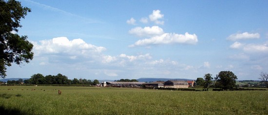
The battlefield comprises a very low north-south ridge with land falling away gently on the west side and hardly at all on the east side, except at the northern end, where a small valley cuts back from the north. It may be significant that, despite it being just a slight fall of the land, that troops on east side of the battalia would probably not have been be able to see the action on the other side unless a narrow frontage was maintained.
SETTLEMENTS & TOWNSHIPS
The battlefield as currently defined lies mainly within the historic township of Brompton with a the western part lying in Northallerton township. The pattern is however a complex one, for there is a detached portion of Brompton township to the west divided from the main township by a narrow tongue of Northallerton township.
Given the relatively highly nucleated settlement pattern of this part of Yorkshire, it is unlikely that any dispersed farms existed in the battlefield area in the 12th century. The dispersed pattern of farms across this landscape at present is likely to have been a post medieval dispersal of settlement, with no buildings being identified on Ogilby’s map of 1676 along the main road, though this is not a definitive guide.
LAND USE
The only significant original reference to the terrain within which the battle was fought is the mention of what is usually translated as ‘in a very wide plain’. The English Heritage report attempts to identify this with the plain associated with woodland that was mentioned in the Domesday (1086) entry for Northallerton, suggesting a large tract of uncultivated land. This interpretation in itself is open to considerable question, but more fundamental is the question of the translation of Aelred’s original Latin: 'in campo lattissimo juxta Alvertonam', which is probably more correctly ‘in broad open field’, meaning the arable strip fields associated with one or more of the adjacent medieval settlements, probably mainly that of Brompton within whose township most of the traditional battlefield lies.
Later interpolation in one version of Aelred gives 'in campo lattissimo, scilicet super Cottwen more juxta Northaldertonam', meaning in the broad open field, namely upon Cottwen Moor next to Northallerton. The latter identification as moor is supported by the 1765 reference to Little Moor. At some time this had probably been quite extensive area of moorland because the 1st edition Ordnance Survey mapping shows the area to the north east as Brompton Moor, to the west as Wiske Moor and to the north west there is Moor Barn in Lazenby. The exact extent of any moor is not known. That at least part of the area was open field in the medieval period is confirmed by both the presence of some ridge and furrow on the battlefield, and the reference to Leeze in various field names, while the 1st edition Ordnance Survey maps show a pattern of long, narrow parallel hedged enclosures which are indicative of early inclosure of open field strips. It is therefore likely that a large part of this area had been encompassed by the open fields of the adjacent townships by the high medieval period. But, given that the battle was fought in 1138 these open fields may not have reached their maximum extent by that time and some of the area later under ridge and furrow may not yet have been taken, although some land may have fallen down to moorland in the recession which followed the Black Death.
This may have been an area where a number of townships shared moorland. Brompton has a detached portion of its township to the west of Cinnamire. It may even be that Cowton in the medieval period had detached rights in this area and that the battlefield area was indeed Cowton Moor, although this is pure speculation at present. The presence immediately north west of the battle field of the names Crowford Farm and Crowfoot Lane might also be significant in this context.
The character of the landscape has of course been completely transformed by inclosure into hedged fields. None of the townships have any enclosure by Act of Parliament, indicating it was enclosure by agreement, all probably largely completed before the mid 18th century. Although a small fragment of open field o the east of Northallerton was still open field in the 18th century, the battlefield area was probably late medieval or early post medieval enclosure, and almost certainly completed by 1675 when Ogilby shows the road to be already enclosed all the way from Northallerton to Lowsey Hill and beyond.
COMMUNICATIONS
For a battle of such an early date there are usually fundamental questions about the nature of the road system, particularly the degree to which particular Roman roads were still in use and the degree to which the major road network first recorded in detail in the later 17th and 18th centuries had already come into existence. In the case of the present A167, the former Great North Road where is runs between Northallerton and Darlington is first mapped in circa 1250 and was regularly used by King John and other kings of the 13th century. It was already one of the most important roads in the whole kingdom and the main route on the east side of the country leading to Scotland. It is therefore extremely likely that the road ran on or very close to its present course in 1138. Detail of the exact alignment and character of the route is not however recorded until 1676, when it is seen to run almost exactly on the current course, with the exception of a dogleg, onto the line of the Northallerton Rigg past Brick House, a little to the south west of the battlefield. The route was not significantly altered by turnpiking in the 18th century. The dogleg, now just a lane, was not abandoned until later in the 18th century took it onto the course of the.
Diverging from the A167 southward and running on through Brompton is the Brompton Lane. Although no evidence has yet been identified for this, it may be that this was a significant route in the 12th century, leading to the Roman road south to Thirsk and thus York.
Joining these two roads to the south of the junction, along what we have interpreted as the approximate location of the English lines, is a small lane called Scotpit Lane. Despite showing the English deployment some distance to the north, Warner suggests Scot Pits Lane was probably a deeply hollowed way and thus used as a defensive position by the English. The evidence on the ground does not support this, for it is not hollowed at all, indeed it now has a central cambered surface. Though this may be a 19th century modification it will not have removed deep hollowing. It is possible that the lane did not exist until after inclosure but this cannot be determined without archaeological investigation. In 1891 the Scotpits Lane was grass grown but still open but a cottage had been built at the dog leg at some time since the 1st edition 6 inch Ordnance Survey mapping. The cottage is now no longer extant and the lane severely overgrown.


