The Battlefield
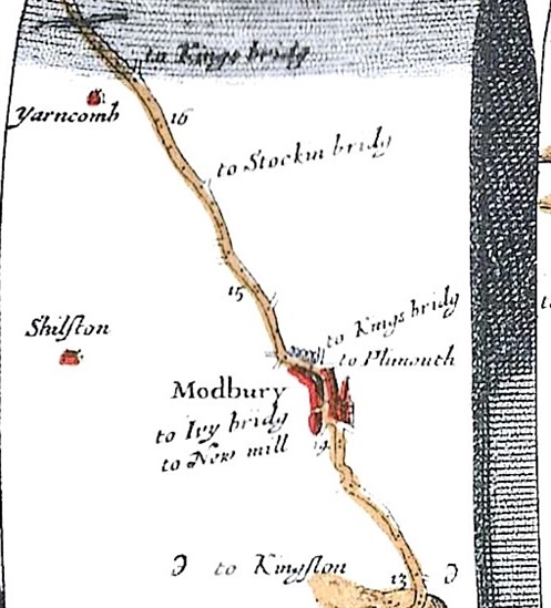
John Obilby’s strip map of the road from Plymouth to Dartmouth, which shows the town of Modbury in 1675 (see map image), first series Ordnance Survey mapping, and information from the Devon and Dartmoor HER allows a preliminary view to be developed of the landscape around Modbury in 1643 (see pdf download on left).
Ogilby’s map clearly shows the road network connecting Modbury with other places in Devon. Immediately to the east of the town, side roads to Plymouth and Kingsbridge are depicted, the latter ultimately joining what is now the A379, the route taken by the parliamentarians to advance on Modbury. Another turning to Kingsbridge is shown further to the east and the Kingsbridge force could have approached the town by either or both routes. A road to Ivybridge (now Brownston Street) can also be seen on Ogilby’s map whilst the road to New Mill, extant at the start of the 20th century, now terminates within the New Mills Industrial Estate. The main road through Modbury shown by Ogilby now consists of Church Street, Broad Street and Galpin Street and the Devon and Dartmouth Historical Environment Record (HER) indicates that the market cross stood at the junction of Church Street, Broad Street and Brownston Street, with the market no doubt occupying Broad Street. The church of St George is also depicted on Ogilby’s map in the south-west corner of the town. Nearby was the manor house belonging to the Champernoun family, who had been given permission to crenulate the building in Edward III’s reign, suggesting it was probably a substantial and defensible building.
Using the six inches to one mile first series Ordnance Survey map of Modbury it is possible to identify some of the town’s burgage plots, long enclosed areas of land immediately behind a house, established in the medieval period. This combined with the depiction of Modbury in Ogilby’s map allows an estimation to be made about the extent of the town in the mid seventeenth century. Ogilby’s map is also drawn with continuous lines for the main road to the east of Modbury and for most of the road to the west which indicates the fields on either side of the road were enclosed, almost certainly by hedges. This corresponds to accounts from the battle indicating that the parliamentarians were surprised by royalist musketeers in the hedgerows. According to those accounts, the hedged fields ran for at least a half mile ‘compass’ (ie, circle) around the town.
To the north-west of the town the Devon and Dartmoor HER suggests there was an area of parkland, Sheepham park, possibly to hold deer. If this was the case, then the park is likely to have had a substantial fence to keep the deer in and poachers out, which may have been a barrier to parliamentarian manoeuvre if an attempt was made to encircle the town on the north side. To the south of the town a deep gully a little to the east of St George’s church is likely to have impeded any movement in this part of the battlefield


