Battlefield Walk
5 miles. Partly across arable, partly on metalled tracks and partly on quiet minor roads. Two fairly steep ascents. If the extra walk to Thorpe Hill, where the rebel army may have started, is included then another 2 miles must be added. The walk described here is meant to be used in conjunction with the Battlefield OS Explorer map, which can be downloaded from the area on the left of the screen.
The ideal starting point is Chipping Warden village, where there are two pubs and it is easy to park close to the church, just off the A361. To shorten the walk by 1 mile, start from Edgcote, parking immediately adjacent to the church but taking care not to park on private ground, not all of which is enclosed.
Immediately east of Chipping Warden church is the base of the market cross. This was a market village in the medieval period, although the market was long since disused by 1469. 100 yards south of the cross take the path on the left, between the gate piers beside the small former gate lodge to Edgcote House. Having crossed the stream the path goes past the front of Edgcote House, where it runs along what was the main street of the medieval village of Edgcote. Little remains of the village today but the field on the right, now parkland to the House, is full of the earthworks remains of the medieval settlement, part of which was probably still in existence at the time of the battle. Edgcote House was built in the 18th century, to replace the medieval manor house which probably stood nearby, but just past it is the medieval church which still stands on the former high street, just as it did at the time of the battle. The church is usually locked but, although it has excellent 16th century monuments, there is no memorial of any kind relating to those killed in the battle to warrant the trip to collect the key.
At the top of the road turn right and then take the footpath across the field immediately on the left. The landscape of Edgcote has been transformed several times since the time of the battle. First, in the late 15th and 16th centuries, there was the enclosure of the open fields, which in the medieval period had extended across almost the whole of the parish. They were replaced by the hedge field system you see around you today. The landscape was then further altered in the 18th and 19th centuries with the imparking around Edgcote House, including its lake, but also with the laying out of plantations, particularly on the skyline on Edgcote hill to the south. In 1469 few if any of these trees and probably none of the hedgerows existed, except for a small knot of hedged and walled enclosures behind you, around the village itself.
This path leads you across the plain between the village and Edgcote Hill. From here the path joins a private road and ascends the eastern end of Edgcote Hill. From immediately to the east of Edgcote Lodge Farm there are excellent views across the plain northward to the narrow channel of the river Cherwell, while beyond is Jobs Hill rising up onto Warden Hill.
Follow the path around to the south of the farm to view the southern battlefield alternative, with Pembroke’s initial deployment on this hilltop facing south east or east, depening on the interpretation. Until recently there would have been exceptional views from here across what was probably Danes Moor, but now tree planting has started to obscure this important view of the battlefield.
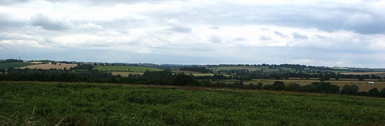
It is possible to continue along this path across the hilltop to loop back to Chipping Warden. But instead our route returns to the east of the farm and then descends from the hill, skirting the north side of Old Spinney. This leads down into the valley believed to be Danes Moor. The plantation to the left in the valley floor is known as Danesmoor Spinney. Here the valley is at its narrowest, and is the site of the battle. The footpath descends the hill, then cuts across Danes Moor as marked on the OS map, before crossing the now culverted over and virtually dried out stream that may be the waterway referred to by Waurin. As the walk crosses Danes Moor, the three hills in Hall are the West Hill, which you have just descended, the East Hill directly in front and the south hill the ridge line off to the right. The area of the valley to the right, southward, provides the alternative location for the battle. When crossing the floor of the valley it becomes clear how closely this area accords with Hall’s description of a plain surrounded by three hills of different heights in a nearly triangular arrangement.
Cross the stream and ascend the smaller hill on the east. Climb to the ruins of the barn on the hilltop for one of the best vantage points on the battlefield site behind you. Although the southern hill, Thorpe Hill, is out of sight to the south, there are excellent views to the south west across Danesmoor and to the west to Edgcote Hill, where Pembroke’s army deployed and then, under attack from the rebel archers, descended to engage the rebel army on the valley floor. The hill on which you stand is the eastern hill around which the rebel reinforcements from Northampton appeared, turning the course of the battle. The path itself may have been a road at the time, for on the next hill to the east there appear to be the remnants of a hollow way on the same alignment.
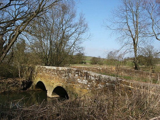
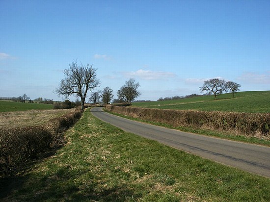
Descend on the east side of the hill and take the path to the north along the valley bottom, marked as the Millennium Way (turning right here takes you up to the south hill (Thorpe Hill), and the area where the Rebel army camped and may have launched their attack according to the more southern interpretation). There are several good viewpoints along this route looking back towards Edgcote Hill. The two small fields on the left of the path just before the road is reached still contain ridge and furrow, the earthwork remains of the medieval strip field system which once covered most of the landscape. There are now only one or two places around Edgcote where ridge and furrow still survives, but as late as the 1940s it still survived in most fields. At the road, where an information board about the battle has been installed by the Battlefields Trust, turn left, taking care around the sharp bends as here there is no verge. At the road junction is Trafford bridge, crossing the river Cherwell, here now just a narrow stream following the extensive changes made during landscaping which saw the introduction of the lake and weir in the centuries after the battle This road across the bridge is an early route known as the Welsh Lane. However it was not named after the Welsh troops that fought at Edgcote. It was simply a drovers’ road leading from Wales towards London, which was still in use as such in the 19th century.
Return to the junction and continue westward along the road on the south side of the Cherwell back to Edgcote, taking care as although this is a very quiet road there is no footway or verge. Finally retrace your steps past Edgcote church and House. In Chipping Warden in the 19th century, somewhere to the south of the churchyard, a mass grave and some individual graves were discovered containing spurs and other artefacts. It is possible that these burials relate to the battle and that they represent fleeing troops from Pembroke’s army that were caught and cut down as they tried to make their escape, trapped by the river Cherwell and the streets, gardens and paddocks of the village.


