A Battlefield Walk
The battlefield lies on farmland to the north of the town of Northallerton (North Yorkshire). It is normally approached along the A167 Northallerton to Darlington road. There is a lay-by on the east (southbound) side of the road about 2.5 miles from the centre of Northallerton. At the layby there is the battle monument and an information board. This is positioned on the English lines according to the traditional interpretation but near the centre of the battlefield according to the re-interpretation presented here.
THE WALK
3 miles. Along the verge of a major road, so requiring great care. The nearest shops, pubs and other facilities, including toilets, will be found in Northallerton, 2 miles to the south. The walk described here is meant to be used in conjunction with the Battlefield Explorer map, available from the download area on the left of the page.
The views presented here are mainly taken from the A167 and the Brompton Lane, with a few from the Scot Pits Lane. The best views of the battlefield and the ones which the commanders on both sides would have enjoyed, are those form the top of the slight north-south ridge that is Standard Hill but are not currently accessible, the Scottish position being on private land and the English position being difficult of access along Scot Pits Lane, though it can just be traversed with great difficulty from the western end.
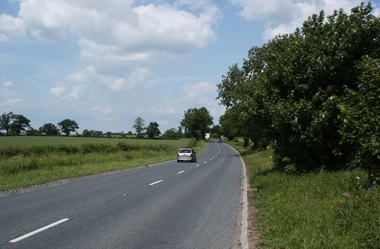
On the west side of the road opposite the lay-by, no more than 30m into the field is the low scarp dropping down to the wide flat area, extending into several adjacent fields, that represents the site of Cinnamire, which is believed to have been an area of open water or marshland at the time of the battle. This, together with the Great North Road, is likely to have been a key factor in the decisions as to where the English army should deploy. Although there is an excellent view of the site of Cinnamire from the other side of the road to the lay-by, crossing to the west side of the road is not recommended due to the speed of traffic on the A167.
The only walk, and that recommended by Kinross and by Clarke, is to go north along the verge from the layby through the Scottish lines and turn right into the Brompton Lane, following the Lane southward down to and just beyond the eastern end of the Scot Pits Lane, to the English lines and the area of the main action. The lane is no longer passable from this side and so one has to retrace one's footsteps to the lay-by. Although the A167 road verge is said to be regularly used by walkers it is not a pleasant walk and could be dangerous if not treated with great care, due to the volume and especially the speed of the traffic, while the Brompton Lane, although having far less and slower traffic, is narrow and generally lacks a significant verge. Incidentally, Wainwright’s Coast to Coast walk skirts the northern edge of the battlefield.
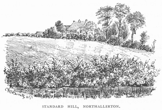
From the lay-by the southern Standard Hill Farm can be seen on the rise to the east. This is traditionally the site of the English battalia, but in the re-interpretation it is just forward of the Scottish lines.
150 m to the north of the lay-by there is a clear view of the northern Standard Hill Farm, the traditional site of the Scottish battalia.
Immediately north west of the junction of the Brompton Lane with the A167 on the west side of the road the slight scarp is clearly visible close to the edge of the field dropping down into the small basin which was another small carr encompassing the whole of the field at some time in the past.
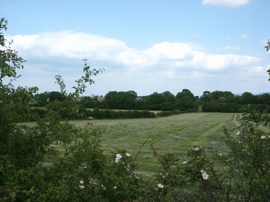
Take the right hand turn into Brompton Lane which then soon turns right again. About 150m to the east of the Brompton Lane is the former area of marsh known as Leascarr which may have been a significant feature at the time of the battle. It is not however very easily seen fro the Lane due to high hedgerows. Once to the south of Leascarr the ground becomes a wide almost flat plain, the slopes of Standard Hill being very gentle.
When the hedges are well maintained it is possible from various locations along the Brompton Lane to see the dark silhouette of the Pennines to the west, some 15 miles away, and on the east just 5 miles away the North York Moors. From here one can really appreciate what a relatively narrow corridor it was for armies striking south into the heart of England, especially when one then takes into account the vast tracts of land that were marshland or at least very poorly drained in the Vale of York. It is easy to see why so many battles were fought in the narrow strip of Land running south towards York and just beyond.
950 m south of the corner a road joins from the left. The end of Scot Pits Lane is 200m further south on the left, but it is currently impenetrable from this side. Just before the Lane there are views of the Scot Pits fields and just to the south of the Lane is the area of Standard Leeze, which we have interpreted as the probable position of the centre of the English deployment. From here it is necessary to retrace ones steps.
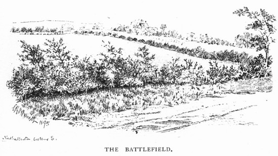
450 yards (400 m) to the south of the lay-by is the western end of Scot Pits Lane, leading east to the Brampton Lane. It is now somewhat overgrown, especially at the eastern end, and fenced off at both ends with barbed wire. However it is just possible, with great difficulty to penetrate along half its length to gain an excellent view from the centre of the English lines. This lane without doubt provides the best vantage points on the whole battlefield. Clarke found it a cheerless place but on a warm summer afternoon it can be a very pleasant spot, despite its proximity to the busy A167 which is soon left behind.
The lane is not currently on the Definitive Map, but a request to add it is pending and the lane appears to have been used for at least the last 100 years by members of the public to visit and view the battlefield.
Drive
Finally, for a broad but distant overview of the landscape the only good option is the brow of the hill (about 2 miles from the battlefield) on the south east side of Brompton. Take the Brompton Lane, possibly the English approach route to the battlefield, south to Brompton (just under 2 miles from the A167 junction). Go through the village and straight on along Banks Road which runs south east from the village, crossing the A684 bypass (about 1.5 miles north east of Northallerton). It rapidly climbs a steep hill from which there are excellent distant views back across the broad plain where the battlefield lies. This lane however is narrow and parking is difficult.


